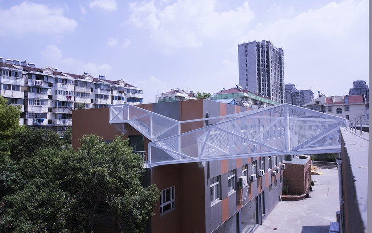
Elevation is often framed as progress, lifting movement above the friction of the city and smoothing circulation into uninterrupted flow. Every act of lifting produces a secondary condition in its wake. Beneath flyovers, metro lines, and railway viaducts, a second ground emerges as shaded, ambiguous, and rarely planned with the same intent as what moves above. These spaces are not incidental leftovers. They are the spatial consequence of a design decision that privileges speed, clearance, and efficiency, redistributing value and visibility across the city in the process.
What lies below is not empty. It is structured, constrained, and defined by infrastructure, left without a clear role. Studies on elevated highways consistently describe these undercroft zones as residual spaces, formed when transport systems are conceived independently of the ground they pass through. An Arup report on spaces beneath viaducts notes how they often disrupt pedestrian continuity while remaining outside formal planning frameworks. Similarly, recent academic reviews of under-flyover environments highlight that these areas are rarely integrated into urban design strategies at all. The result is a peculiar condition: space that is physically present and structurally determined, but programmatically undefined.
In 2012, Cities Without Ground: A Hong Kong Guidebook offered one of the clearest documentations of a condition that many residents experience intuitively but rarely name: Hong Kong's dependence on elevated, second-storey urbanism. Through drawings and careful mapping, the book captured how the city's pedestrian networks are routinely lifted above the street—separating people from traffic, extending commercial frontage beyond ground level, and negotiating a hilly topography where "flat" circulation is often an engineered achievement. Since its publication, these systems have only grown in prominence—not only for their sheer spatial complexity, but for the way they recast public space as something continuous yet selective, connective yet curated.
This fascination, however, has always carried a parallel unease. Elevated passages can be generous and effective, offering sheltered movement and reliable connectivity. Yet they also raise persistent questions: where do these routes lead, who gets to connect, and what kinds of programs are invited—or excluded—by this "privileged" level of circulation? The second-storey city does not simply bypass vehicles; it can also bypass the street as a civic stage. Over time, it risks shifting architectural attention away from ground-level public life, relieving designers from having to negotiate pedestrian scale, frontage, and the messy reciprocity of the street. In its worst moments, the result is a landscape of podium clusters and sealed megastructures—buildings that perform connectivity at Level 2 while remaining indifferent to the neighborhood at Level 0.
Transcending their role as mere infrastructure, bridges have long served as powerful architectural statements. This expressive potential is now being explored with renewed vigor across South-East Asia, where a growing number of architects are re-evaluating traditional materials. By championing wood and bamboo, these designers are creating distinctive structures that integrate local craftsmanship with contemporary needs, resulting in landmarks that are both functional and deeply rooted in their landscape.
Large-scale infrastructure projects often aim to connect distant locations within urban areas, facilitating quicker transportation, logistics, and commercial activities along their routes. However, while these projects link distant destinations, their substantial physical presence can significantly affect local communities. This may result in the disconnection and disengagement of previously connected neighborhoods, the disruption of public spaces, and generally negative outdoor experiences caused by noise, pollution, and lack of attention and maintenance to these infrastructures.
Nevertheless, several successful built environment projects have re-integrated contentious infrastructure into the community through thoughtful design of outdoor spaces, with Paris' Coulée verte René-Dumont being one of the first examples and New York's High Line being one of the most prominent examples. The High Line demonstrates how well-conceived outdoor projects can address the alienation caused by extensive infrastructure, foster community reconnection, serve as cultural and economic hubs, and even spur further economic redevelopment, as in Hudson Yards.
“The Mindfulness City will be a sustainable city. To be mindful is to be aware — to perform best,” said Giulia Frittoli, partner and head of landscape at BIG. The Kingdom of Bhutan is a landlocked Buddhist country in the eastern Himalayas, nestled between China and India. It covers 14,000 square miles and has a population of nearly 800,000.
The Royal Office of Bhutan asked BIG, Arup, and Cistri to develop a plan for a new Mindfulness City in Gelephu in southern Bhutan, near the border with India. The city will span 386 square miles and include a new international airport, railway connections, hydroelectric dam, university, spiritual center, and public spaces.
The technical needs of the construction of bridges many times guide the development of the design itself. However, architecture is never put aside, rather the opposite. The aesthetics of bridges that we collect in this article are the result of an intense, demanding, and stimulating dialogue between architecture and engineering, where the search for solutions only ends when both disciplines are fully satisfied.
Whether figuratively or in an urban context, bridges are a strong symbol and often become iconic projects in cities. Building bridges can mean creating connections, new opportunities. But they are also fundamental pieces of infrastructure that solve specific issues in an urban context. As these involve highly technical equipment, with complex constructions and overwhelming bold structural requirements, they require projects that do not need full integration between architecture and engineering and, in many contexts, is a type of projects that architects are not so involved with. Marc Mimram Architecture & Engineering is a Paris-based office comprised of an architecture agency and a structural design office. In its project portfolio, there are several bridges, as well as various other project typologies. We spoke with Marc Mimram about his latest project in Austria, the bridge at Linz, photographed by Erieta Attali.
Architecture remains in constant tension with natural forces. Designed around gravity, climate, and time, buildings are always part of larger systems. Throughout the world, designers have tried to mitigate natural forces by constructing hybrid spaces and structures, artificial areas where nature meets the manmade. Embodying this relationship, canals reflect a desire to direct nature and its flows. Today, these fluid spaces are opening up to new programs, projects that explore modern life and urban vitality.
A new 550-ton steel bridge has been placed next to the new United States Olympic and Paralympic Museum in Colorado Springs. The bridge was designed by the same team as the adjacent Olympic & Paralympic complex - Diller Scofidio + Renfro, Anderson Mason Dale, and KL&A - while taking inspiration from the motion of athletes. The design features a 250-foot curved steel structure that was made to float above the rail yard.
KILD has been announced as the first place winner for a design competition in Kaunas, Lithuania’s second largest city. The competition sought for innovative and eco-friendly proposals for a pedestrian and cycle bridge that would connect the downtown area to Science Island.
The AIANY + ASLANY Transportation + Infrastructure Design Excellence Awards recognize exceptional design by New York, New Jersey, Connecticut, and Pennsylvania AIA and ASLA members. The awards program is open to registered architects, landscape architects, and planners.
In a country famous for its below sea level towns, combating flooding has been a key challenge for Dutch designers for centuries, resulting in the construction of numerous dikes, levees and seawalls across the country. But when tasked with creating a new pedestrian link across an urban river park in Nijmegen, NEXT Architects and H+N+S Landscape Architectsdecided to try a different approach: to celebrate the natural event by designing a stepping stone bridge that only becomes useful in high water conditions.
Known as the Zalige Bridge, the structure was completed in March 2016, but only just was given the opportunity to prove itself in January 2018, when water levels in the park rose to 12 m NAP+, the highest point in 15 years.
Rogers Stirk Harbour + Partners (RSHP) and Aedas have unveiled the design of a new boundary crossing that will serve as an important transportation exchange point within the Pearl River Delta, linking Hong Kong, Macau and mainland China. Already under construction, the project is expected to be completed in 2019.
Originally slated to be built in place, further research concluded that the design would have placed too much stress of the canal walls. So it was back to the drawing board, and the studio, where the updated design is now under construction. Featuring complex curves and a 12-meter-span, the bridge is now being constructed by MX3D’s sophisticated 3D-printed robot. And with about one-third of the structure already completed, it is back on schedule for a late 2018 installation on Amsterdam’s Oudezijds Achterburgwal canal.
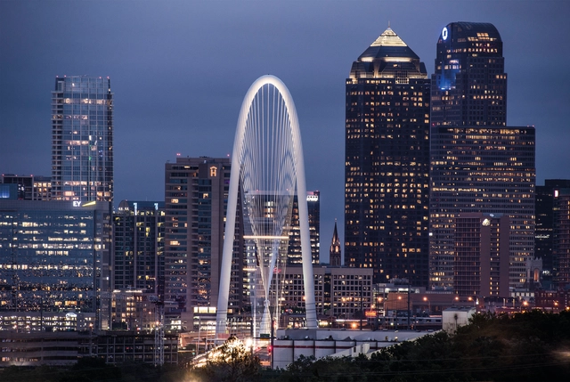
Increasingly close collaboration between architects and engineers has caused an explosion in bridge design over the last few decades, resulting in structures that are both bold yet rational. As a result, cities have exploited bridges as great monuments of design, to foster pride in the residents and promote themselves as a destination for tourists. These ideas have inspired photographer Greig Cranna as he travels the world, capturing the elegance of today's bridge infrastructure.
Cranna has been documenting some of his stunning photography on Instagram, collating it over the past 20 months into a forthcoming book, Sky Architecture—The Transformative Magic of Today's Bridges. In capturing these entrancing structures, the photos show the impact of the bridges as an addition to the landscape and revel in their contemporary silhouettes and designs.
The bridge today (Aug 24). Image Courtesy of New York Governor's Office
The long-awaited replacement for New York City’s longest bridge, the Tappan Zee, is set to open to the public on Friday, announced Governor Andrew Cuomo. After four years of construction, the first of the $4 billion dollar project’s twin two-span cable-stayed structures will welcome automobile as well as pedestrian and bicycle traffic for the first time.


.jpg?1534024322&format=webp&width=640&height=580)


.jpg?1524664344 "© Bing Zhang")


.jpg?1524664377 "© Bing Zhang")


. Image Courtesy of New York Governor's Office")
. Image Courtesy of New York Governor's Office")


